🎯 For Developers, Builders & Project Teams
If you need more than photos and overhead maps—and want a true 3D understanding of your site—this case study shows how drone capture can support digital twin and BIM workflows.
This project focuses on 3D reconstruction of a real construction site and how that connects directly to modern Virtual Design & Construction (VDC) practices.
I currently offer through Overwatch Drone Mapping (VDC Studio):
- 3D drone modeling & digital twin creation
- Orthomosaics & top-down site maps
- Construction progress capture
- BIM-aligned site documentation
Watch this week’s video 👇:
📩 Request pricing or book a project:
Context: What This Case Study Was
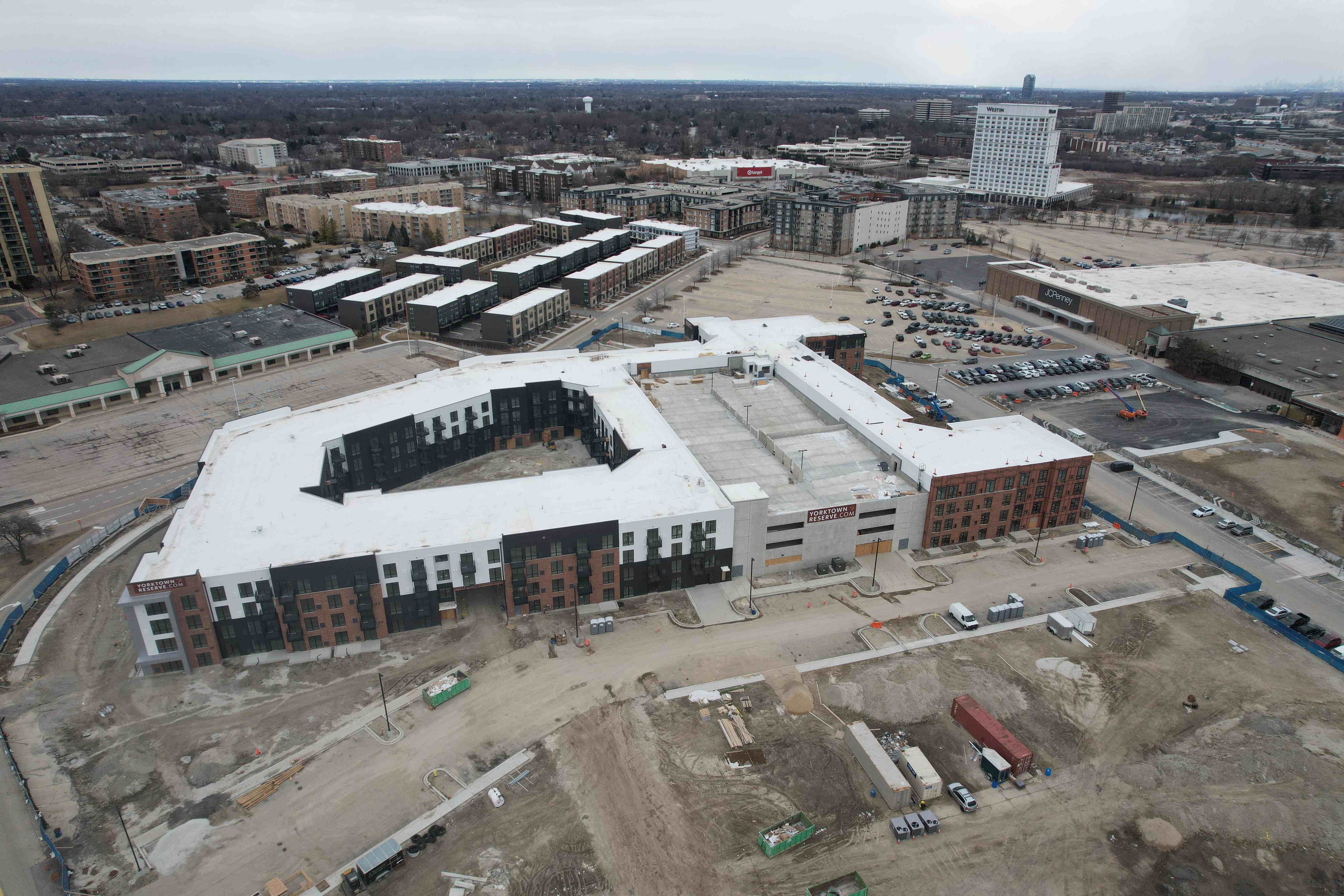
This project focused on capturing and reconstructing a condominium construction site in 3D using a structured drone orbit flight.
The subject property was the Yorktown condo development, and the goal was to create a clean, navigable 3D model that reflects current construction conditions.
Unlike the previous case study, which emphasized 2D mapping + site context, this one explores:
➡️ How aerial capture feeds 3D spatial reconstruction
➡️ How that reconstruction supports digital twin workflows
➡️ How drone data connects directly to BIM environments like Revit
This is Case Study #3 in an ongoing real-world series building a drone-based VDC pipeline.
The Objective
The mission focused on:
- Executing a clean orbit flight around the structure
- Capturing full facade and roof coverage
- Generating a photogrammetry-based 3D model
- Evaluating the model for BIM / digital twin alignment
The deliverable needed to answer:
- What does the building look like right now in 3D?
- How accurate is the geometry and massing?
- Can this be referenced in design or planning workflows?
- How useful is this for progress documentation?
The Capture Process: Orbit-Based 3D Data Collection
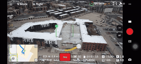
1. Structured Orbit Flight
Instead of grid mapping, this mission used a controlled orbital flight path around the building.
Key capture priorities included:
- Consistent distance from the structure
- Multiple vertical angles
- Full facade coverage
- Roof visibility
- Clean overlap for photogrammetry processing
The purpose here isn’t just imagery—it’s geometry reconstruction.
The better the capture, the cleaner the model.
The Output: Photogrammetry 3D Model
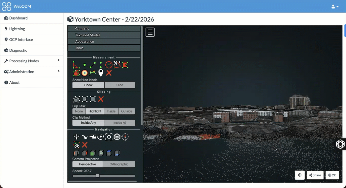
The captured imagery was processed into a photogrammetry-based 3D mesh model of the building.
This output provides:
- Accurate building massing
- Real-world facade conditions
- Spatial relationships to surroundings
- A navigable 3D environment
Unlike traditional photos or video, this allows stakeholders to:
- Inspect from any angle
- Understand scale instantly
- Review progress remotely
- Reference real-world conditions without visiting the site
From Drone Model → BIM & Digital Twin Workflow
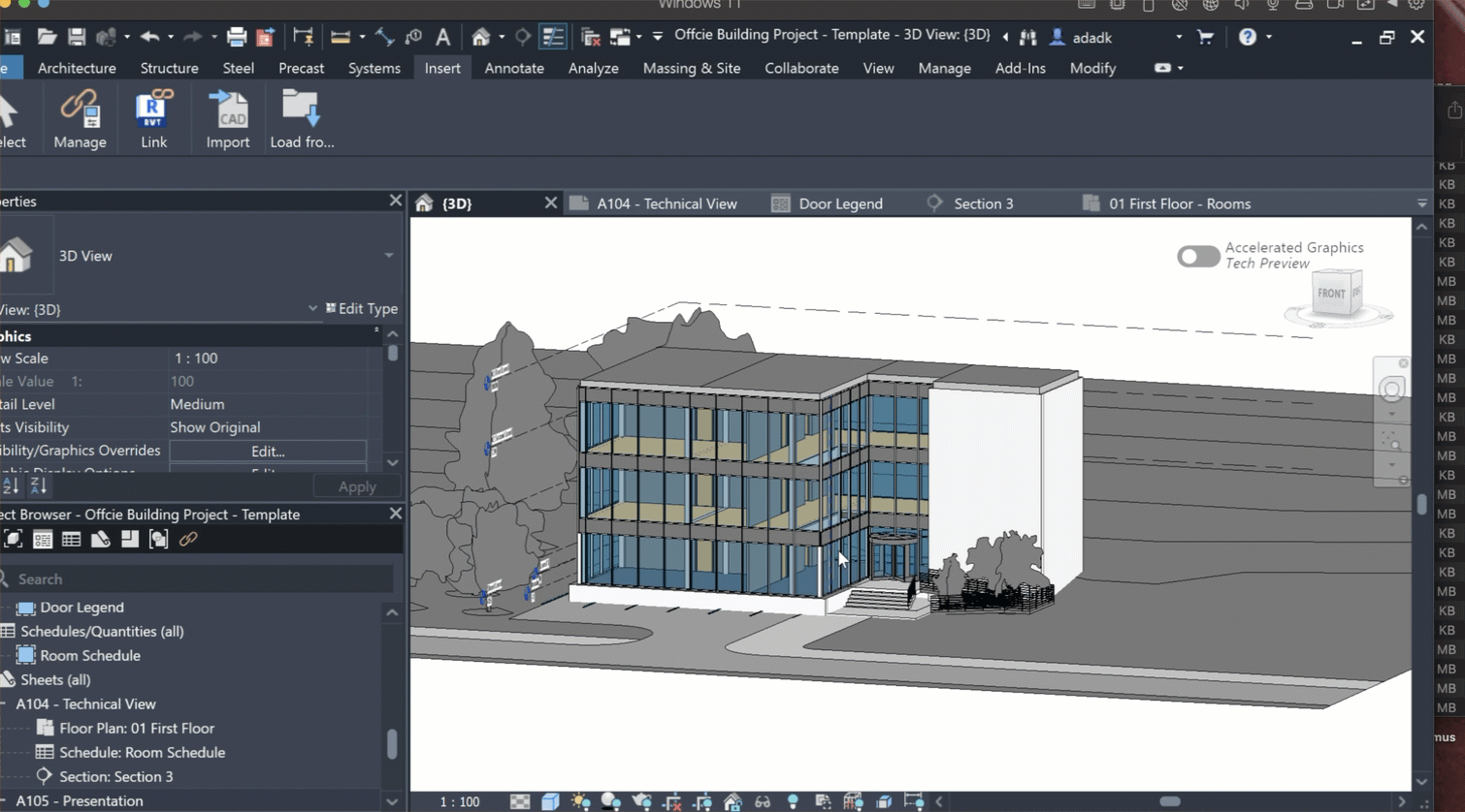
This is where the workflow becomes powerful.
I’m currently training and working inside Revit, which is a leading BIM (Building Information Modeling) platform used by architects, engineers, and contractors.
The connection:
Drone Model (Reality Capture)
⬇
3D Mesh / Site Geometry
⬇
Reference for BIM Modeling in Revit
This creates the foundation for a digital twin workflow:
A digital twin is a digital representation of a real-world asset that can be used for:
- Design coordination
- Construction planning
- Renovation analysis
- Lifecycle asset management
The drone model acts as real-world truth, while BIM models represent designed intent.
When combined, teams can:
- Compare design vs actual
- Track progress over time
- Identify discrepancies early
- Improve coordination between field and design teams
What This Project Produced
Final Deliverables Included:
- Photogrammetry 3D model (mesh + textured)
- Exported model views (video + stills)
- Web-shareable model preview
- Progress documentation visuals
- Written case study + workflow notes
📦 Download the full project files here:
👉 GUMROAD LINK – Case Study #3 Files
Why This Matters for Builders & Developers
This type of capture provides something most sites don’t have:
➡️ A true 3D record of the project at a moment in time
This is useful for:
- Construction progress documentation
- Investor / stakeholder reporting
- Pre-renovation analysis
- Marketing & leasing visuals
- Dispute resolution documentation
And most importantly:
It creates the foundation for BIM-integrated site workflows.
How This Fits Into a Scalable VDC Service
Through Overwatch Drone Mapping, this evolves beyond media into a VDC-aligned service stack:
- 2D orthomosaic site maps
- 3D site & structure models
- Progress tracking over time
- BIM reference geometry
- Digital twin datasets
This creates:
- Higher-value retainers
- Recurring monthly documentation
- Integration with design teams
- Clear deliverables with repeatable pricing
Learn the Business Side
This case study is part of building Overwatch Drone Mapping in public.
If you’re interested in building a similar service:
📘 Drone Income Blueprint – BOOK LINK
Inside I break down:
- Service packaging
- Pricing structure
- Client acquisition
- How to position mapping vs media work
Services I Currently Offer
I currently offer VDC-aligned drone services for:
- Developers
- General contractors
- Real estate teams
- Property owners
Core services include:
- 3D drone modeling & digital twins
- Drone mapping & orthomosaics
- Construction progress capture
- Aerial site documentation
📩 View packages or book a project:
Building This in Public
This is Case Study #3 of an ongoing series.
Each project expands the workflow:
1 → Mapping foundations
2 → Context + site understanding
3 → 3D modeling + BIM alignment
Next case studies will include:
- Larger multi-building sites
- Paid developer projects
- Time-based progress tracking
- BIM comparison workflows
- Pricing breakdowns & retainers
Location: Chicago Area
Project Type: 3D Drone Modeling / VDC Support
Category: Case Study