🎯 For Developers, Builders & Property Owners
If you need clear, decision-ready site visuals—not just aerial footage—this case study documents how drone capture and on-the-ground context work together on a real job site.
This project shows how aerial data becomes useful when paired with physical site awareness.
I currently offer:
- Drone site mapping & documentation
- Orthomosaics & overhead site visuals
- Construction progress capture
- Real estate & development support
Watch this week’s video 👇:

📩 Request pricing or book a project:
Context: What This Case Study Was
This project was a real-world site mapping job, focused on documenting an active property using both aerial capture and a physical site walkthrough.
Unlike Case Study #1—which centered on validating a repeatable mapping workflow—this project emphasized context.
The goal wasn’t just to generate an orthomosaic.
It was to understand how aerial data and ground-level observation inform each other.
This is Case Study #2 in an ongoing series documenting real drone mapping work as it’s learned, refined, and applied.
The Objective
This mission focused on:
- Capturing structured aerial imagery
- Walking the site to observe constraints and access points
- Producing a clean orthomosaic for analysis
- Evaluating how aerial perspective supports real decisions
The deliverable needed to answer practical questions:
- How is the site laid out?
- Where are the access routes?
- What relationships aren’t obvious from the ground?
- What would matter to a developer or contractor reviewing this remotely?
The Process: From Flight to Field Context
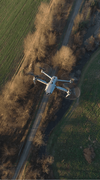
1. Aerial Capture
The flight was structured for coverage and consistency, not cinematic movement.
Key considerations included:
- Stable altitude across the site
- Consistent overlap for mapping
- Predictable flight paths
- Clean image capture for stitching
The goal was to produce imagery suitable for a high-quality orthomosaic—one that could actually be used, not just viewed.
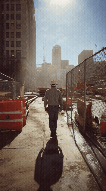
2. Ground Walkthrough
Immediately after capture, I walked the site.
This step is critical and often overlooked.
From the ground, you notice:
- Access limitations
- Elevation changes
- Surface conditions
- Physical obstacles
- Context not obvious from above
These observations directly influence how the aerial data is interpreted.
Aerial imagery shows what exists.
Ground context explains why it matters.
The Output: Orthomosaic & Site Overview
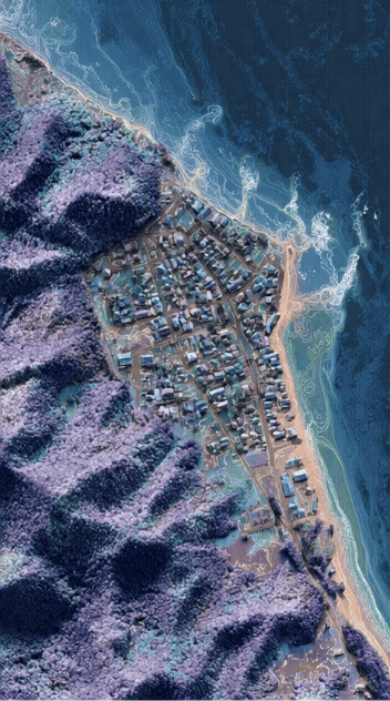
The captured imagery was processed into a high-resolution orthomosaic, producing a scale-consistent, top-down view of the site.
This output provides:
- Accurate spatial relationships
- Clear layout understanding
- A shared reference for discussion and planning
Unlike standard photos, an orthomosaic removes perspective distortion, allowing the site to be reviewed objectively.
This makes it useful for:
- Planning conversations
- Remote review
- Documentation
- Baseline records
What This Project Produced
Final Deliverables Included:
- High-resolution orthomosaic (GeoTIFF)
- Web-friendly orthomosaic image
- Annotated map (PDF)
- Detailed written case study
- Field observations & insights
📦 Download the full project files here:
👉 GUMROAD LINK – Case Study #2 Files
Why This Case Study Matters
This project highlights an important truth:
Drone mapping is most valuable when it’s context-aware.
Aerial data alone can miss nuance.
Ground observation alone can miss scale.
Together, they provide:
- Better situational awareness
- Fewer assumptions
- Clearer communication
- More confident decisions
This is what turns drone work from “cool visuals” into a professional service.
How This Fits Into a Scalable Business
Projects like this are the foundation for:
- Construction progress documentation
- Pre-development site evaluation
- Renovation before/after records
- Developer reporting
- Long-term retainers
Compared to traditional real estate video, mapping-focused work offers:
- Clear scope
- Fewer revisions
- Higher perceived value
- Repeatable pricing
Learn the Business Side
This case study is part of building Overwatch Drone Mapping in public.
If you’re interested in turning mapping and aerial services into real income, I documented the business framework separately:
📘 Drone Income Blueprint – BOOK LINK
It breaks down:
- Service packaging
- Pricing logic
- Client positioning
- Scaling beyond one-off jobs
Services I Currently Offer
If you’re a builder, developer, or property owner, I currently offer:
- Drone mapping & site documentation
- Construction progress capture
- Real estate aerial media
- Orthomosaics & overhead analysis
📩 View packages or book a project:
Building This in Public
This is Case Study #2 of an ongoing series.
Every project is real.
Every workflow is documented.
Every improvement builds on the last.
Upcoming case studies will include:
- Larger-scale sites
- Paid client work
- Progress tracking
- Pricing breakdowns
- Workflow refinements
Location: Chicago Area
Project Type: Drone Mapping / Site Documentation
Category: Case Study