At Overwatch, we focus on helping buyers and sellers understand not just the home — but the environment around it.
As part of our ongoing collaboration with Dream House Real Estate, we’re releasing a new educational short that highlights a common blind spot for buyers: external neighborhood factors that are difficult to assess from ground-level photos alone.
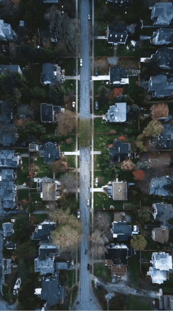
Things like road proximity, traffic flow, noise patterns, and nearby development often become clear only after moving in. Drones give us a way to evaluate these elements before decisions are made.

What Buyers Often Overlook
When touring a home, most attention goes to interiors, finishes, and layout. But long-term livability is heavily influenced by what surrounds the property.
Buyers may miss:
- Major roads just beyond tree lines
- Rail lines or industrial corridors nearby
- Traffic congestion during peak hours
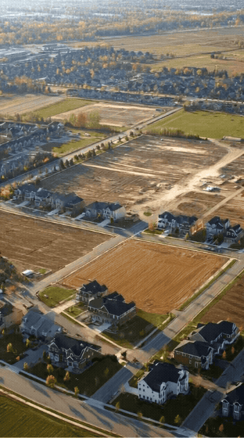
- Vacant land slated for future development
- Commercial zoning adjacent to residential areas
These factors don’t always show up in listing photos — but they absolutely affect daily life.
Why Ground-Level Photos Aren’t Enough
Traditional listings typically show:
- Interior rooms
- Front and backyard angles
- A few exterior elevations
What they rarely show is context.
From the ground, it’s hard to understand how close a home is to:
- Busy intersections
- High-traffic corridors
- Construction zones
- Schools, parks, or commercial centers
This is where drone footage becomes a decision-making tool, not just a marketing asset.
How Drones See the Bigger Picture
Aerial perspectives allow buyers to evaluate a property as part of a living system, not an isolated structure.
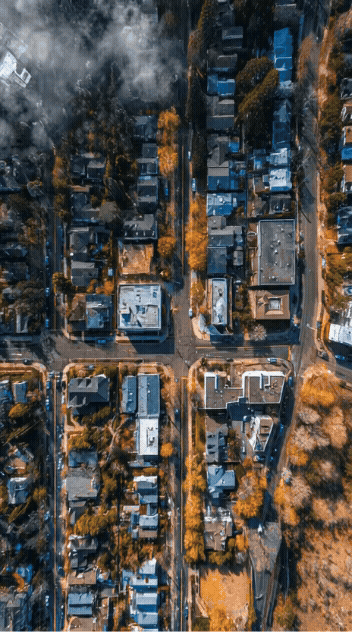
Drone views help reveal:
- Traffic patterns throughout the block
- Noise sources like highways or rail lines
- Density of surrounding homes or buildings
- Open land vs. active development
- How quiet or active an area really is
In a city like Chicago, where neighborhoods can change block by block, this visibility matters.
Quiet, Busy, or Still Developing?
One of the most valuable insights drone footage provides is pattern recognition.
From above, you can quickly tell whether an area is:
- Established and stable
- Actively developing
- Transitional or mixed-use
- Adjacent to expanding infrastructure
This context helps buyers plan not just for today — but for the next phase of the neighborhood.
Why This Matters for Buyers and Agents
For buyers, drone context helps align expectations with reality.
For agents, it adds transparency and trust.
For sellers, it ensures the right audience understands the property upfront.
Drone footage doesn’t replace inspections or due diligence — it simply helps everyone ask better questions earlier.
Behind the Scenes: Building Overwatch (Week 3)
While we’re publishing polished educational content, we’re also building Overwatch in public.
In this week’s vlog, we’re sharing our minimum viable product — a simple but honest step forward. For now, that means a screen recording of FPV flight practice in Uncrashed, paired with webcam commentary.
It’s not flashy — but it’s real progress.
Learning in Public, Improving in Real Time
Every professional drone operation starts with fundamentals: flight control, spatial awareness, and consistency.
This MVP phase represents:
- Skill-building before services
- Transparency over perfection
- Long-term thinking over shortcuts
We’re documenting the learning curve because understanding how tools are built matters just as much as seeing the final result.
Technology With Context
At Overwatch, we believe drone media is most powerful when it adds understanding, not just visuals.
Whether it’s lot lines, neighborhood noise, traffic flow, or development patterns, our goal is to help people see what’s otherwise easy to miss.
What’s Next
Upcoming content will cover:
- Real-world neighborhood analysis using drones
- FPV vs cinematic flight use cases
- Applying aerial context to real estate decisions
- Continued behind-the-scenes progress building Overwatch in Chicago
More soon.