At Overwatch, we use drone technology to make real estate information clearer, more visual, and easier to understand — especially in a dense and complex Chicago real estate market.
As we begin our first drone mapping project, we’re also releasing an educational short with Dream House Real Estate focused on an often-overlooked topic: lot lines — and why they matter when buying or selling a home.
Understanding property boundaries isn’t just a technical detail. In Chicago, where lots can be tight, irregular, or shaped by decades of development, clarity can directly impact value, negotiations, and long-term use.

What Are Lot Lines?

Lot lines define the legal boundaries of a property. They determine:
- What land is included in the sale
- Where structures can be built, expanded, or modified
- Responsibility for fences, driveways, alleys, and shared access
- Potential zoning or neighbor disputes
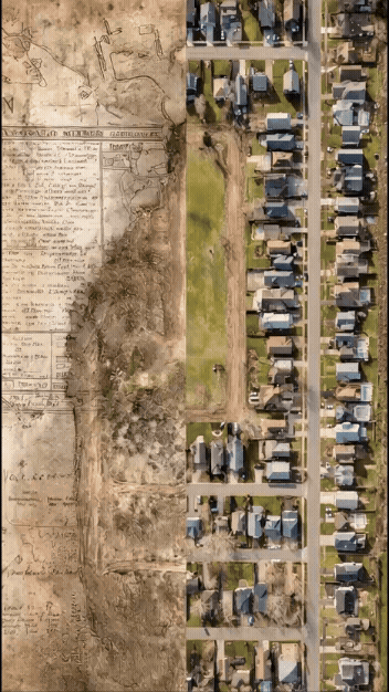
In Chicago neighborhoods, lot configurations vary widely — from standard city lots to irregular parcels — making boundary clarity especially important.
Why Lot Lines Matter in Chicago Real Estate
For buyers, unclear lot lines can lead to surprises after closing, including limited usable space or unexpected easements.
For sellers, uncertainty can slow negotiations or reduce perceived value.
For agents, plats and legal descriptions are often difficult for clients to visualize.
Drone mapping turns abstract boundaries into clear, understandable visuals.
The Limitations of Traditional Listing Photos
Most listings rely on ground-level photos and static maps. These often fail to show:
- The full extent of the property
- How structures relate to boundaries
- Usable outdoor space
- Proximity to neighboring buildings
This is where misunderstandings commonly begin — especially in competitive Chicago markets.
How Drone Mapping Adds Clarity
Drone mapping allows us to create high-resolution aerial imagery and overlay approximate lot lines to provide spatial context.
This helps:
- Buyers understand what they’re purchasing
- Sellers present land more confidently
- Agents communicate boundaries visually
- Reduce confusion earlier in the transaction
Drone mapping does not replace a licensed land survey, but it is a powerful educational and marketing tool.

Why We’re Launching a Mapping Project at Overwatch
As Overwatch grows, we’re expanding beyond traditional drone photography into mapping, spatial data, and context-driven visuals.
This project represents:
- More informative real estate media
- Better visual support for due diligence
- A focus on clarity over hype
Our collaboration with Dream House Real Estate reflects this philosophy.
Behind the Scenes: Building Overwatch
We’re documenting this process publicly. In our latest vlog, we explain why we’re starting this mapping project and how it fits into Overwatch’s long-term vision.

Education First, Technology Second
Technology only matters if it helps people understand something better. Whether it’s lot lines, zoning considerations, or property layout, our goal is to simplify complex real estate information visually.
What’s Next
This mapping project is just the beginning. Upcoming content will cover:
- Real-world drone mapping workflows
- How aerial data supports smarter real estate decisions
- Lessons learned building a drone services company in Chicago
More to come.